
State Route 74 — the Ortega Highway — begins its climb into the Cleveland National Forest right at San Juan Capistrano, just inland from San Clemente and Dana Point, and within minutes it becomes one of the most notorious motorcycle roads in California. Locals and riders alike know sections of it by nicknames that don’t leave much to the imagination: Dead Man’s Curve, Ricochet Alley, Blood Alley. For riders based in South Orange County, the Ortega isn’t some distant, occasional destination — it’s often the closest genuine canyon road, and a regular weekend ride for many. This post looks at what makes this specific stretch of road so dangerous, how fault typically gets analyzed in an Ortega Highway crash, and what riders and their families should know if the worst happens.
Why This Specific Road Is So Dangerous
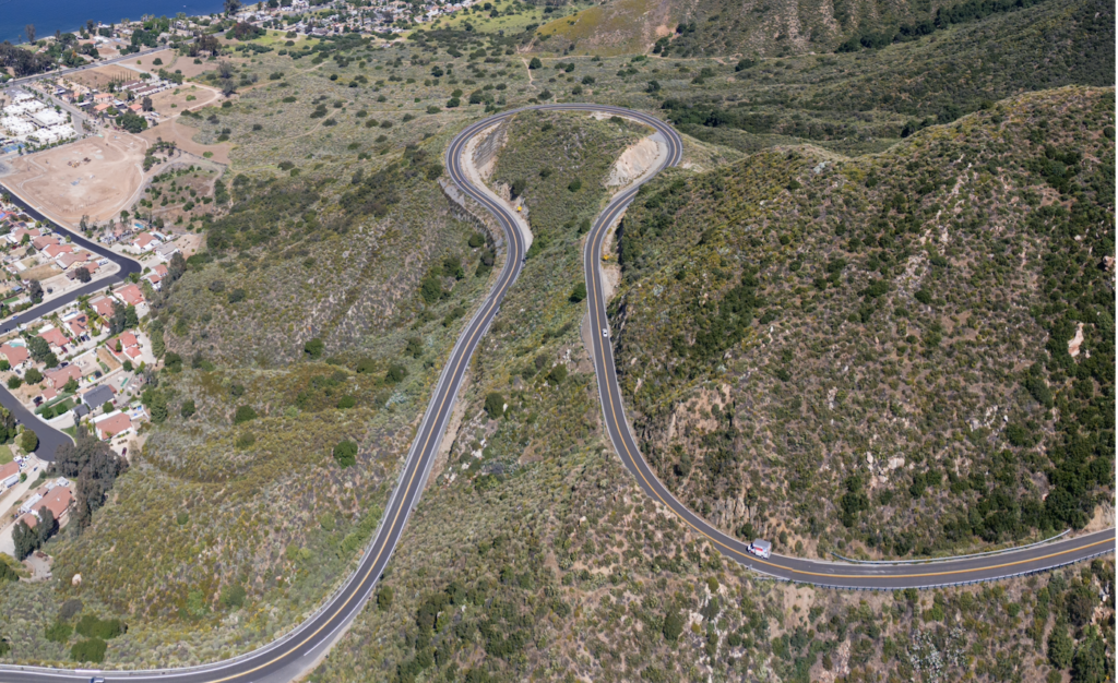
The Ortega Highway runs roughly 28 miles from San Juan Capistrano to Lake Elsinore, mostly as a two-lane road without a center divider, winding through the Cleveland National Forest with hairpin turns, blind curves, steep drop-offs, and long open stretches that alternate unpredictably with tight, low-visibility bends. Independent research from UC Berkeley traffic safety researchers found that 57 people died along the 28-mile Orange County-to-Riverside County stretch between 2011 and 2023 — and 35 of those fatalities, roughly 61%, were motorcyclists. That concentration of motorcycle fatalities on a single stretch of two-lane road is a genuinely striking figure, and it reflects a combination of factors specific to this highway rather than motorcycling risk in general.
The road’s blind curves are a central issue: sightlines around many of the tightest bends extend only a matter of feet, meaning a rider leaning into a turn may have almost no warning of an oncoming vehicle drifting across the center line, road debris, or another vehicle stopped ahead. Without a physical median separating opposing traffic for most of the route, a driver or rider who drifts even slightly wide on a blind curve creates a head-on collision risk that a divided highway simply doesn’t carry. The steepest and tightest sections tend to cluster on the descent toward the Riverside County side, where grade changes compound the difficulty of judging speed through successive curves.
The Complicated Question of Fault
California Highway Patrol officers who patrol the Ortega Highway regularly have noted that a substantial majority of motorcycle crashes statewide — figures cited around 78% — are found to be the fault of the motorcyclist, typically tied to excessive speed for the road’s curves. This statistic is worth understanding carefully rather than taking at face value in any individual case: it reflects statewide patterns across all types of roads and doesn’t mean that a rider is presumed at fault in any specific Ortega Highway accident, or that other drivers, road conditions, or vehicle defects can’t be the actual or contributing cause.
In practice, fault analysis on a road like this one tends to focus on several recurring factors:
- Speed relative to the specific curve, not just the posted limit. A speed that would be entirely safe on a straight highway can be genuinely dangerous entering a blind hairpin turn. Both riders and drivers can be found to have contributed to an accident by failing to adjust speed appropriately for the specific geometry of a curve, independent of whether they were technically within the posted speed limit.
- Centerline crossings. Given the lack of a physical median for most of the route, a vehicle or motorcycle that drifts across the centerline — whether from misjudging a curve, overcorrecting, or simply cutting the apex of a turn too aggressively — is a common and often decisive factor in head-on and near-head-on collisions. Establishing which vehicle crossed the centerline, and by how much, is frequently the central factual question in an Ortega Highway crash investigation.
- Road conditions and hazards. Debris, gravel washed onto the roadway from surrounding hillsides, pavement deterioration, and wildlife are all recurring contributors to loss-of-control accidents on this stretch, and a rider who loses control due to an unmarked or unaddressed road hazard may have a claim against the entity responsible for maintaining that section of highway — generally Caltrans, since SR-74 is a state highway — separate from any claim against another driver.
- Following distance and passing maneuvers. The Ortega’s long open stretches, interspersed with sudden curves, create a temptation for impatient passing that this road’s geometry doesn’t always safely accommodate. A driver or rider who passes into a blind curve, misjudging the available sightline, bears significant responsibility for any resulting collision.
Comparative Negligence on a Road Like This
Because the CHP’s fault statistics can create a misleading impression that a rider is automatically at fault in any Ortega Highway crash, it’s worth being clear about how California law actually works: the state’s pure comparative negligence rule applies here exactly as it does everywhere else. Even if a rider bears some responsibility for excessive speed or an aggressive line through a curve, a driver who crossed the centerline, passed unsafely, or otherwise contributed to the collision can still bear a meaningful share of fault — and the rider’s compensation is reduced by their own percentage of responsibility, not eliminated by it. Given how often insurers may lean on this road’s general statistics to argue a rider was inherently and solely at fault, a careful, curve-by-curve reconstruction of the actual accident is often what determines whether that assumption holds up.
When a Crash Is Fatal: What Families Should Know
Given how disproportionately fatal accidents on this specific stretch of road are for motorcyclists — a fatality rate that stands out even compared to other dangerous California highways — it’s worth briefly addressing what happens legally when an Ortega Highway crash doesn’t survive. California allows a deceased rider’s surviving spouse, children, or in some circumstances other dependents to bring a wrongful death claim, which can include compensation for lost financial support, loss of companionship, and funeral and burial expenses, among other damages. Separately, the deceased rider’s estate can generally bring a survival action for damages the rider personally experienced between the time of the crash and death, along with any medical or related expenses incurred. These are legally distinct claims with different eligible claimants and different available damages, and given the frequency with which this specific road produces fatal outcomes, families dealing with the loss of a rider on the Ortega Highway are, unfortunately, not navigating an unfamiliar situation for an experienced South Orange County injury attorney.
What Makes Ortega Highway Cases Different to Investigate
Sparse or absent witnesses. Long stretches of the Ortega run through undeveloped forest land with minimal traffic and no nearby businesses or residences, meaning independent witnesses are often harder to come by than in a typical urban accident. This makes physical evidence at the scene — skid marks, debris fields, gouge marks in the pavement, and the final resting positions of the vehicles — proportionally more important than it would be in a well-witnessed intersection collision.
CHP investigation quality varies with scene complexity. Given how frequently CHP officers respond to crashes on this specific corridor, investigating officers often have relevant institutional knowledge about which curves see repeat incidents — knowledge that can be genuinely useful to a case, but that also means it’s worth obtaining and carefully reviewing the full CHP report rather than assuming a brief roadside assessment captured every relevant detail.
State highway maintenance issues require a different claims process. If a road defect, inadequate signage, or a known hazard that Caltrans failed to address contributed to a crash, a claim against the state involves the same Government Claims Act framework discussed in our post on train safety near the Metrolink crossings — meaning a six-month deadline to file a claim, rather than the standard two-year window, if a state entity’s negligence in maintaining the highway is part of the case.
Practical Safety Considerations for Riders
While this post focuses primarily on the legal picture, a few practical points are worth including given how specifically this road has earned its reputation. Riding within your own skill level rather than the pace of a group, maintaining extra following distance on blind curves specifically, and treating any curve you can’t see through completely as a potential hazard — regardless of how many times you’ve ridden that stretch before — are all reasonable, low-cost precautions on a road where sightlines are consistently the limiting factor in avoiding a collision.
What to Do If You’re Involved in an Ortega Highway Accident
- Get medical attention promptly, even away from immediate cell service. Given how remote portions of this route are, don’t assume help will arrive as quickly as it would in a more developed area — call 911 as soon as you’re able and provide the most specific location information you can (mile markers, nearby landmarks, or GPS coordinates if available).
- Document the specific curve or section involved. Given how much fault analysis on this road depends on the exact geometry of a specific curve, noting precisely where the accident occurred — ideally with photographs of the road itself, not just the vehicles — is more important here than on a typical intersection accident.
- Request the full CHP investigation report. Given the CHP’s extensive experience patrolling this specific corridor, their report often contains detailed observations about sightlines, skid evidence, and centerline position that matter significantly to establishing fault.
- Consider whether a state highway maintenance issue contributed. If debris, pavement deterioration, or a known hazard played a role, this may open a separate claim against Caltrans, subject to the shortened government claims deadline.
- Reach out to a group ride companion or club, if applicable, for corroborating accounts. Given how many riders travel the Ortega in groups, a fellow rider who witnessed the moments leading up to a crash — your speed, positioning, and the other vehicle’s behavior — can provide exactly the kind of independent corroboration that’s otherwise scarce on this remote stretch of highway.
- Don’t assume statewide fault statistics apply to your specific crash. As discussed above, the commonly cited figure that riders bear fault in a majority of motorcycle crashes statewide reflects broad averages across every type of road and riding scenario in California, not a legal presumption applicable to your individual case — an insurer’s early reliance on this statistic is a negotiating position, not a finding of fact.
The Ortega’s reputation is well-earned, but it isn’t a reason to assume liability is automatically settled against a rider simply because of where the crash occurred. Every case still turns on its own specific facts.
A Beautiful Ride, Worth Riding Carefully
The Ortega Highway draws riders for good reason — it’s one of the more genuinely scenic canyon roads within easy reach of South Orange County. But its reputation isn’t exaggerated, and the same features that make it appealing to ride make it unforgiving of misjudgment, whether that misjudgment comes from a rider, another driver, or a road hazard neither of them created.
If you or a loved one has been injured in a motorcycle accident on the Ortega Highway or anywhere in South Orange County, Rosen Law Offices offers free consultations to help you understand your options. Call us at (949) 335-0020.
This article is intended for general informational purposes and does not constitute legal advice. Every accident involves unique facts, and the outcome of any claim depends on the specific circumstances involved. If you’ve been injured, consult with a licensed attorney about your particular situation.